These maps show bird species richness (the number of unique bird species), which is estimated within 100 square kilometer areas. In Los Angeles County, bird species richness ranges from 9 species to as many as 97! Patterns of bird species richness coincide with those of environmental factors, such as rainfall (higher richness can be observed along the coast and mountain ranges, and lower richness in drier and hotter desert areas).
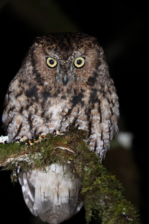
In Los Angeles, nocturnal breeding birds primarily include owls. The most common nocturnal bird in Los Angeles is the Great Horned Owl, followed by the Barn Owl which has a near global distribution. Species like the Western Screech Owl, Northern Pygmy Owl, California Spotted Owl, and Northern Saw-whet Owl are solitary and occur in mountainous areas with forest.
With their large eyes and binocular vision, owls are well adapted to low-light conditions. They are also able to hear in 3D due to their slightly offset ears and ability to rotate their head and hear at different angles. Nocturnal bird surveys or “owling” is challenging. However, scientists are now using sound loggers to survey nocturnal birds and improve our understanding of their distribution in Los Angeles.
Wetland breeding birds, including ducks, herons, grebes, cormorants, rails, and blackbirds, require freshwater wetlands. Over the last century, both coastal and inland wetlands in the LA Basin have been significantly reduced. These rare habitats are now restricted to a small number of protected areas. The highest wetland bird species richness in Los Angeles County occurs at the Piute Ponds on Edwards Air Force Base (north of Lancaster). There are also a number of urban locations, such as the Sepulveda basin, that contain a high number of breeding wetland birds as well.

Woodpeckers are excellent indicators of ecosystem health. Nine woodpecker species are included in this richness map (Acorn Woodpecker, Williamson’s Sapsuckers, Red-breasted Sapsuckers, Ladder-backed, Nuttall’s, Downy, Hairy, White-headed Woodpeckers, and Northern Flicker).
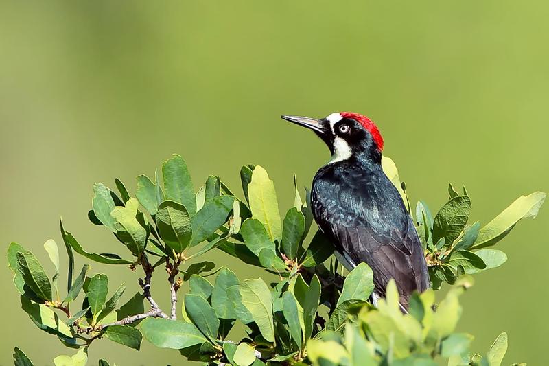
As cavity nesters, woodpeckers have historically required living and dead native trees (e.g. oaks, sycamores, walnuts, pines) in which to excavate space to build their nests. High woodpecker species richness can thus be seen in the forest habitat of the San Gabriel Mountains. But the map also reveals a large swath of southern Los Angeles County with little or no breeding woodpeckers. Dense urban areas typically offer fewer nesting opportunities, as dead or dying trees usually need to be removed due to safety hazards. However, woodpeckers play an important role in their ecosystems; they are often referred to as “ecosystem engineers” because their excavation activities significantly modify ecosystems and allow other species to benefit from their work. Once abandoned, woodpecker cavities are often used by many other birds and mammals, including owls, swallows, bluebirds, and squirrels. The preservation of snags (dead trees) for woodpecker nesting is thus important in natural areas, parks, and other green spaces and rights-of-way wherever possible.
The last map above shows “hotspots” of species of conservation concern. These are endangered, threatened, and sensitive birds that will continue to need protection, management, and habitat restoration in order to continue living here. The five main hotspots are wetlands and waterbodies near Gorman and Lancaster, riparian areas in Santa Clarita, foothills in San Gabriel mountains and Puente Hills, and the Palos Verde peninsula. However, any location in which sensitive breeding bird populations can be found is an in Los Angeles, it represents an important opportunity to protect and restore their habitat.
Data source: Los Angeles County Breeding Bird Survey © LA Audubon 2016
About these maps: The data in these maps have been adapted from the Breeding Bird Atlas, a Los Angeles Audubon Society publication created by Larry W. Allen and Kimball L. Garrett, with maps compiled by Mark C. Wimer. The Breeding Bird Atlas includes data for over 200 breeding bird species in Los Angeles County, based on fieldwork conducted from 1995 to 1999. Over 300 volunteer observers contributed 10,000+ hours to gather more than 28,000 records.
The Breeding Bird Atlas is an excellent model of systematic biodiversity research and surveys. The book contains summaries of breeding bird distributions, habitat requirements, and important conservation indicators (abundance, population trends), as well as maps of confirmed and suspected breeding locations. The Biodiversity Atlas presents summaries of the data at a 10- by 10-kilometer spatial resolution.